Harpeth River State Park: Nashville's Best Escape Into the Wild
Stretching roughly 40 river miles along the lower Harpeth River, this free Tennessee State Park packs archaeological wonders, a 200-year-old hand-dug tunnel, and calm paddling water into a series of non-contiguous sites just west of Nashville. It rewards those who come prepared and take their time.
Quick Facts
- Location
- Cheatham and Davidson Counties, west of Nashville, TN — multiple access sites near US Highway 70 and Kingston Springs
- Getting There
- Car recommended; drive west on I-40 to US-70, then follow signage to your chosen access point. No direct public transit service to park sites.
- Time Needed
- Half day for a single site; full day if paddling and hiking multiple locations
- Cost
- Free to enter; some activities (canoe/kayak rentals, special programs) may have separate fees
- Best for
- Paddlers, history buffs, hikers, families looking for a green escape from the city
- Official website
- tnstateparks.com/parks/harpeth-river
What Harpeth River State Park Actually Is
Harpeth River State Park is not a single, fenced-off campus with a visitor center and a parking lot. It is a linear park, a collection of nine non-contiguous sites strung along roughly 40 river miles of the Harpeth River through Cheatham and Davidson Counties, west of Nashville, Tennessee. Each site has its own character, its own trailheads, and its own reason to visit. That structure is both the park's appeal and the thing most visitors fail to account for when planning a trip.
The park was designed to connect several historically, archaeologically, and ecologically significant sites along the lower Harpeth into a manageable state-protected corridor. The result is one of the more unusual parks in the Tennessee State Parks system: part paddling trail, part archaeological preserve, part industrial history site, part quiet natural area within easy reach of a major city.
💡 Local tip
Before you go: decide which site or sites you want to visit, since the park has no central hub. Check tnstateparks.com/parks/harpeth-river for current access information and seasonal closures, then map your route to the specific parking area you need.
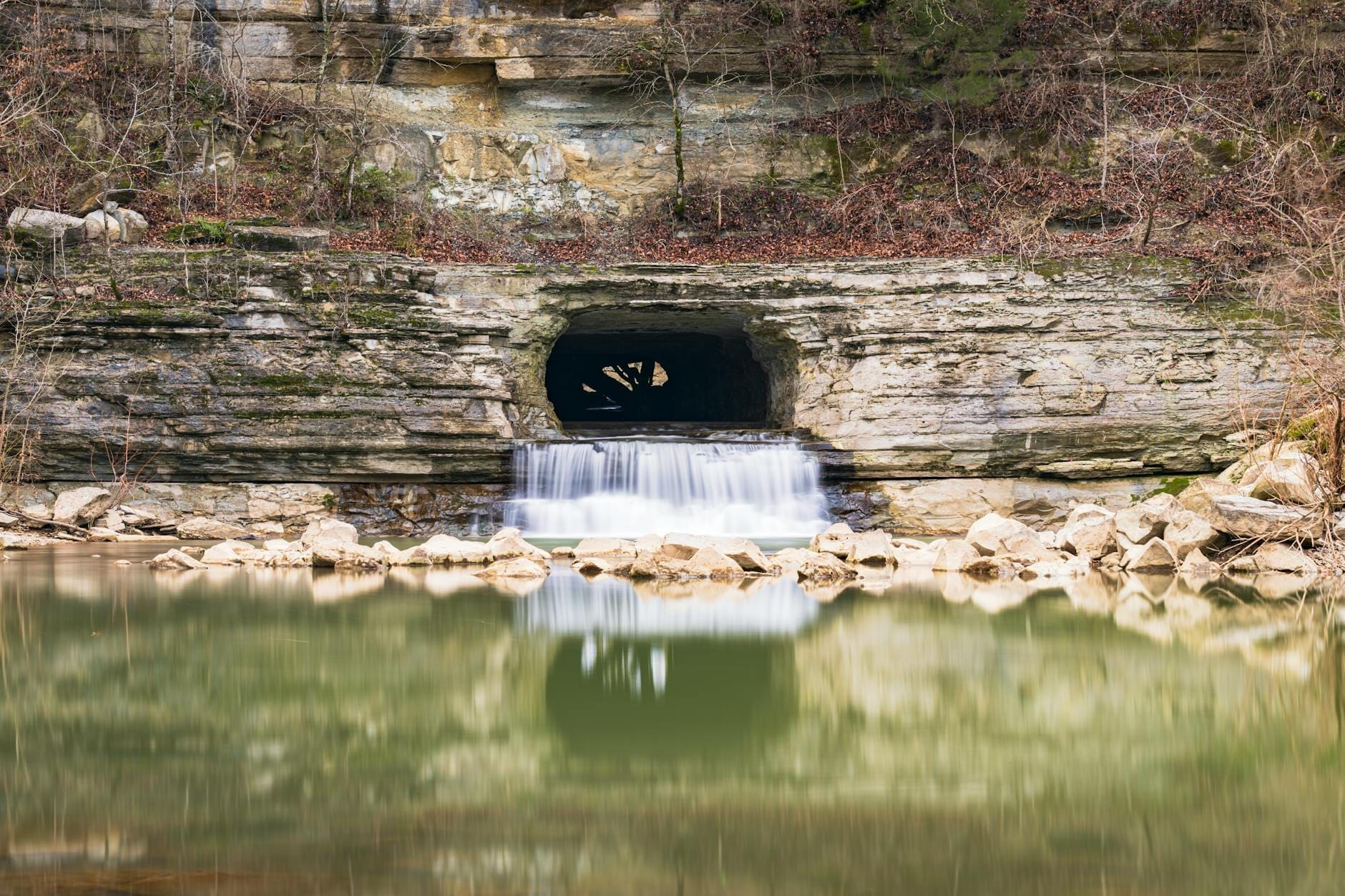
The Montgomery Bell Tunnel and the Narrows of the Harpeth
The most talked-about feature in the park is the Montgomery Bell Tunnel at the Narrows of the Harpeth, and it earns the attention. In 1818, ironmaster Montgomery Bell commissioned workers to hand-dig a tunnel through a narrow ridge of limestone to redirect the flow of the Harpeth River, creating a significant drop in elevation that could power the nearby ironworks later known as Pattison Forge. The tunnel runs approximately 290 feet through solid rock and is, by any measure, a remarkable piece of early 19th-century industrial engineering.
To reach it, you walk a short trail from the parking area down toward the river. The landscape is quiet in the morning hours, when the light filters through the canopy and the only sounds are the water and whatever birds are working the underbrush. The tunnel mouth itself sits low at the waterline, and the scale of the cut-through rock becomes more impressive the closer you get. This is a place where the historical context does most of the interpretive work: knowing that enslaved workers and laborers carved this channel by hand in the early years of American statehood makes the silence feel earned.
The Narrows is also a popular put-in and take-out point for paddlers. On weekend mornings from April through October, you will see a steady rotation of canoes and kayaks at the water's edge. If you plan to paddle this stretch, arrive early to secure parking and be aware that the river level varies significantly with rainfall. After heavy rain, currents that look mild can become genuinely hazardous.
⚠️ What to skip
River safety: Always check current water levels before paddling any section of the Harpeth. The Tennessee Department of Environment and Conservation maintains river gauge data. Levels rise quickly after rain and conditions can change overnight.
Tickets & tours
Hand-picked options from our booking partner. Prices are indicative; availability and final rates are confirmed when you complete your booking.
Old Town trolley tour of Nashville
From 54 €Instant confirmationFree cancellationHatch Show Print guided tour
From 21 €Instant confirmationFree cancellationDowntown walking tour of Nashville
From 21 €Instant confirmationFree cancellationNashville Downtown Underground Donut Tour
From 46 €Instant confirmationFree cancellation
Mound Bottom: The Archaeological Site Most Visitors Never See
Among the park's assets, Mound Bottom stands apart. This is one of the most significant Mississippian-period archaeological sites in Tennessee, a pre-Columbian ceremonial and civic complex dating roughly to 1000-1300 CE. The site contains multiple earthen platform mounds arranged around a central plaza, and the scale of what was once here is genuinely hard to absorb when you are standing in it.
Access to Mound Bottom is restricted and managed by the park to protect the site. Visitors cannot simply drive up and walk in. Ranger-led access programs are available (typically offered seasonally from October through March), and interested visitors should contact the park office at +1 615-952-2099 well in advance to arrange a visit. It is worth doing. The site is not just a patch of grass with historic markers: it is a landscape that has been continuously significant to human communities for more than a thousand years, and the park's care in managing access reflects that.
Paddling the Harpeth
The Harpeth River is widely considered one of the better flatwater paddling rivers in Middle Tennessee. The park manages multiple river access sites across its roughly 40-mile corridor, and many paddlers use these launch points for multi-hour or multi-day float trips. The river runs through forested corridors, past limestone bluffs, and through sections where the surrounding landscape looks nothing like the city 30 miles to the east. For a broader sense of what outdoor options surround Nashville, the hiking near Nashville guide puts the Harpeth in useful context alongside other parks and natural areas in the region.
Canoe and kayak rentals are available through outfitters operating in the area (check the park's official site for current permitted concessionaires, as these can change). If you bring your own boat, the park's non-contiguous layout actually works in your favor: you can shuttle a vehicle to a downstream take-out point, put in upstream, and float a section without retracing your path.
The best paddling months are spring and fall, when temperatures are manageable and water levels are generally stable. Summer paddling is possible but can mean low water in dry years, with more rock-dragging than floating in some stretches. Winter paddling is practiced by experienced paddlers but is not recommended for casual visitors due to cold water immersion risks.
Hiking, Wildlife, and What the Park Feels Like on the Ground
The hiking at Harpeth River State Park is modest in mileage but often high in interest. Trails at various sites wind through bottomland forest, along blufflines, and past historic remnants. The terrain is generally not strenuous, but surfaces are often natural and uneven, meaning appropriate footwear matters more than fitness level.
The forest cover is typical of Middle Tennessee's mixed hardwood landscapes: tulip poplar, sycamore along the riverbanks, cedar on the drier ridges, with pawpaw in the understory near the water. In spring, the riverbanks carry the smell of damp soil and new leaves. In autumn, the bluffs above the river take on color that makes even a short walk worth the drive. Deer are common throughout the park, and the river corridor supports herons, kingfishers, and in some sections, wood ducks.
Families with older children tend to do well at the Narrows and at Hidden Lakes, where the shorter trails and proximity to the water hold attention. For parents planning a broader Nashville trip with kids, the park pairs naturally with other outdoor and discovery stops covered in the Nashville with kids guide.
Planning Your Visit: Practical Notes
The park is open from sunrise to sunset daily, and there is no entrance fee. Parking at most sites is a small gravel lot or a roadside pull-off, and on busy spring and fall weekends these fill up by mid-morning at the most popular access points. If you arrive to find the Narrows parking area full, the lot at Mace Bluff is a short distance away and often has space.
Nashville has no direct public transit service to the park, so a car is essentially required. From downtown Nashville, take I-40 west and exit onto US-70, then follow signage to your chosen access point. Drive times from downtown to the main park areas run approximately 30 to 45 minutes depending on traffic and destination. The park phone number for questions and ranger-led access programs is +1 615-952-2099.
Bring water, since there are no concessions at most sites. Wear layers in shoulder seasons, as temperatures near the river in the early morning can be noticeably cooler than Nashville city temperatures. Ticks are present in the warm months, and trail users should do a full check after walking through any brushy or grassy terrain.
ℹ️ Good to know
Accessibility: Conditions vary significantly between sites. Visitors with mobility considerations should call +1 615-952-2099 before visiting to ask about current trail surface conditions and accessible facilities at specific access points.
If you are building a full day out of the area, the town of Kingston Springs sits near the main park access corridor and offers a stopping point before or after. For those thinking about day trips further afield from Nashville, the day trips from Nashville guide covers options that pair well with a morning at the Harpeth.
Photography and What to Expect Visually
The Narrows of the Harpeth offers the park's most photographically distinct subject: the tunnel mouth framed by the limestone ridge and the river in the foreground. Morning light is better here, since the site is partially sheltered by trees and afternoon sun creates harsh contrast. A wide lens is useful for capturing the scale of the cut; a longer lens picks up detail in the rock texture and the water.
The river itself photographs well in the flat, diffused light of overcast days, when reflections in the water become clear and the greens of the bankside vegetation saturate. In October and early November, the blufflines above the river turn amber and rust, and the combination of fall color and water makes for the park's most rewarding photographic conditions of the year.
The Harpeth is part of a broader landscape of natural areas west of the city. If green spaces and trails are a priority during your Nashville visit, it is worth reading the Nashville state parks guide for a fuller picture of the options, including Radnor Lake and Long Hunter State Park closer to town.
Insider Tips
- The Narrows parking area is the smallest and fills fastest. If you arrive after 9:30 AM on a sunny weekend in April or October, have a backup access point in mind before you leave Nashville.
- Mound Bottom is one of the most significant pre-Columbian sites in the state, but it requires advance arrangement for access. Call the park office at least a week before your visit if you want to see it properly with a ranger.
- Paddling a shuttle trip between two access points gives you a far better sense of the river than an out-and-back from a single launch site. The park website lists access points with distances between them to help you plan your float.
- Pawpaw trees fruit in late August and early September along the riverbanks. If you know what to look for, the bottomland forest near the water produces this native fruit that most visitors walk past without noticing.
- Cell coverage is patchy at several access points. Download your maps and any trail information before leaving Nashville, and do not rely on navigation apps working reliably once you are in the park corridor.
Who Is Harpeth River State Park For?
- Canoe and kayak paddlers looking for calm, scenic flatwater within an hour of downtown Nashville
- History and archaeology enthusiasts drawn to the 1818 Montgomery Bell Tunnel and the Mississippian mound complex at Mound Bottom
- Hikers who want short to moderate trails through genuine Middle Tennessee forest without crowds
- Families with older children who can handle natural, uneven terrain and want a tangible outdoor experience
- Photographers in autumn, when the bluffs above the river carry strong fall color
Nearby Attractions
Combine your visit with:
- Arrington Vineyards
Arrington Vineyards is a working winery set on 95 acres of rolling Tennessee countryside about 25 miles south of Nashville. With 16 acres of estate vines, five tasting rooms, and a calendar full of live music events, it offers a genuinely relaxed alternative to the city's usual attractions.
- Carnton
Built in 1826 and thrust into Civil War history on a single November night in 1864, Carnton in Franklin, Tennessee stands as one of the most significant and sobering historic sites near Nashville. The mansion served as the principal Confederate field hospital after the Battle of Franklin, and four Confederate generals killed in action were laid on its back porch. Today it operates as a museum alongside the McGavock Confederate Cemetery, one of the largest privately owned Confederate cemeteries in the United States.
- Downtown Franklin Historic District
About 21 miles south of Nashville, the Downtown Franklin Historic District packs genuine 19th-century architecture, Civil War history, and an independently owned Main Street into a walkable few blocks. Entry is free, the streets are open all day, and it rewards slower travelers who actually stop to look up.
- GEODIS Park
Opened in May 2022, GEODIS Park is one of the largest soccer-specific stadiums in the United States, seating over 30,000 fans. Home to Nashville SC and a growing concert calendar, it brings serious sports infrastructure to a city better known for music.